Gloucestershire Cycle Spine

Share Gloucestershire Cycle Spine on Facebook Share Gloucestershire Cycle Spine on X (formerly Twitter) Share Gloucestershire Cycle Spine on Linkedin Email Gloucestershire Cycle Spine link
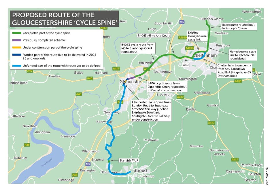
The St Ann Way to Cole Avenue walking, wheeling and cycling improvements scheme forms part of the Gloucestershire Cycle Spine, a route extending across the county from Stroud in the south to Bishop's Cleeve in the north. It will contribute to a significant cycling and walking network across the Gloucestershire County, improving quality and connectivity.

The St Ann Way to Cole Avenue scheme will provide full access to the 26-mile cycle spine from the St Ann's Way / Bristol Road junction to Cole Avenue and Tuffley Lane. The scheme will support a greener Gloucestershire, help reduce carbon emissions, supporting improvements to public health and making it easier for people to cycle, walk and wheel to work, homes and key destinations.

Walking and cycling have great health and wellbeing benefits. If more people walked, cycled or used public transport, it would lead to less congestion. Furthermore, exercising 20 minutes per day cuts risk of developing depression by 31% and increases productivity.

By providing a high quality infrastructure, we hope to see a change from one form of transportation to another. This shift is one of the most effective ways how to reduce transport emissions and noise pollution.

Route and overview

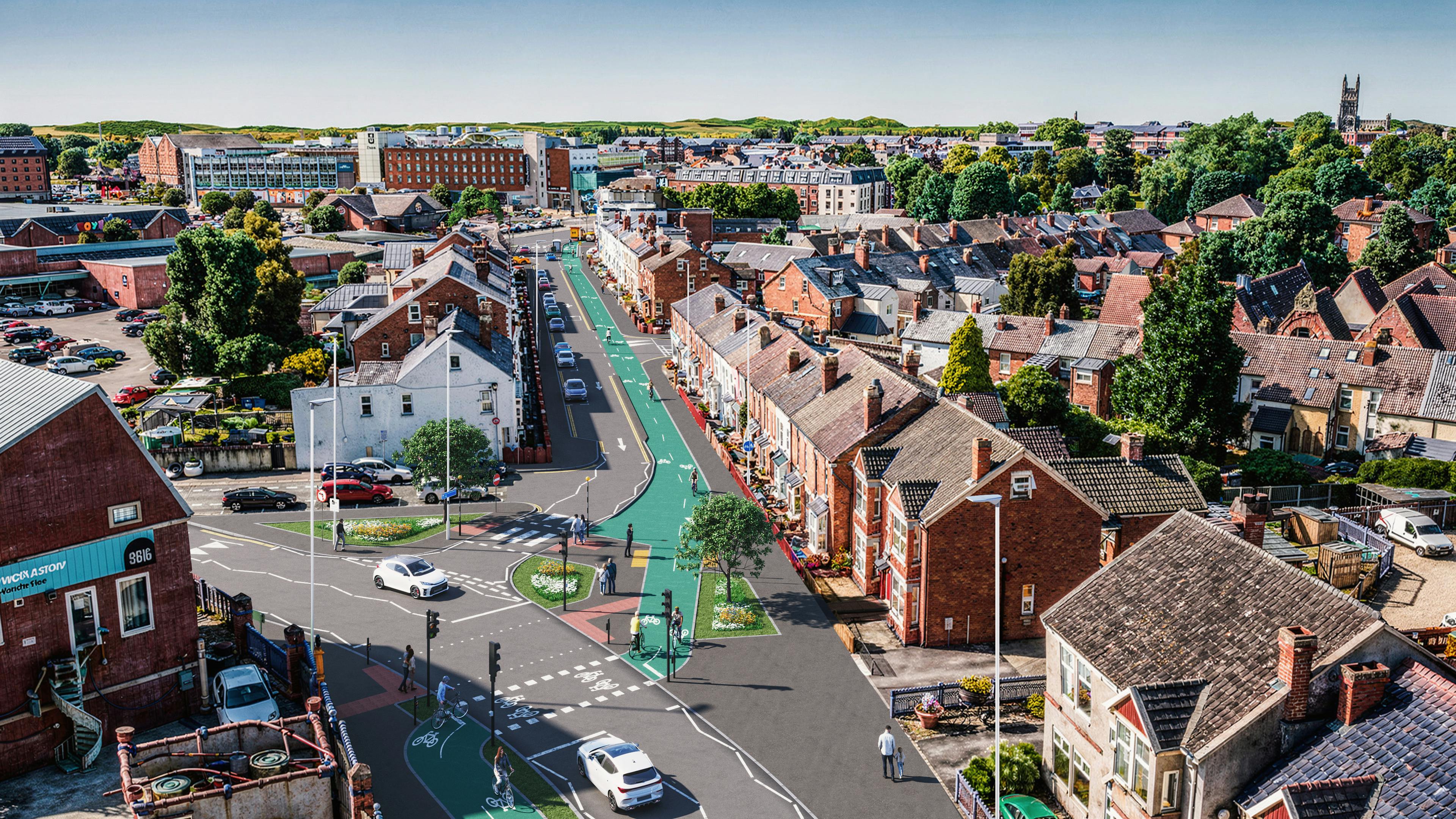
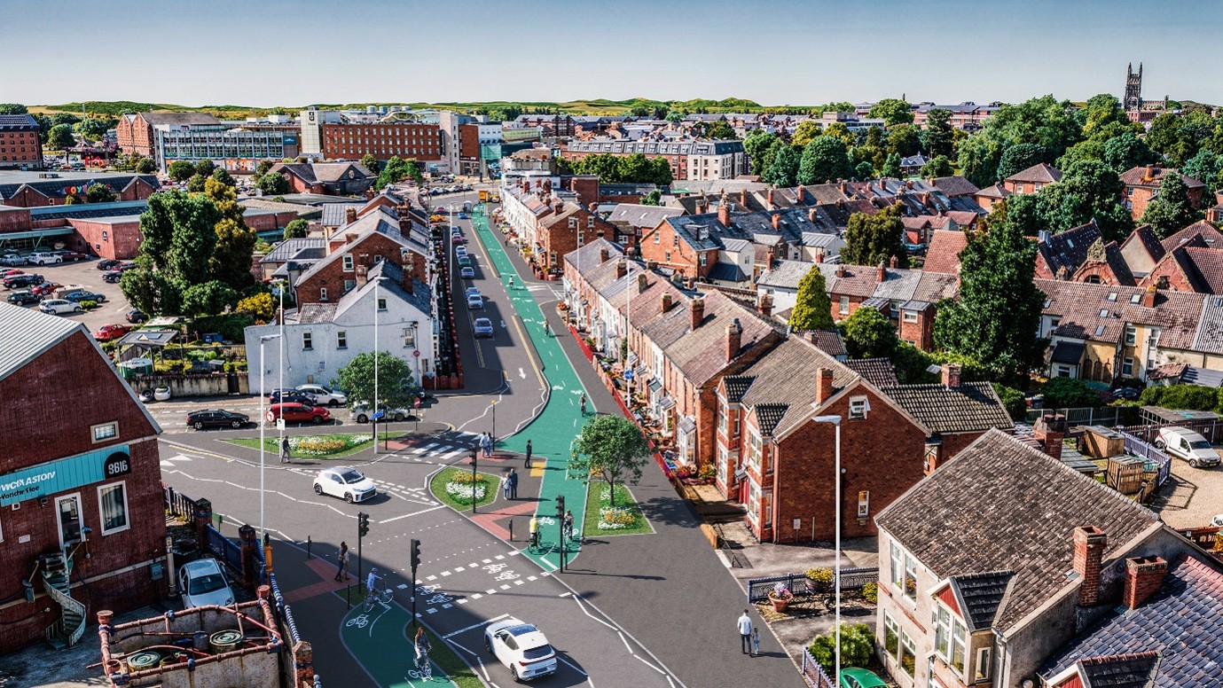
The route will run between the St Ann Way / Bristol Road junction and Cole Avenue, linking into Tuffley Lane, and provide a direct connection to both recently completed and planned sections of walking and cycling improvements through Gloucester City Centre.

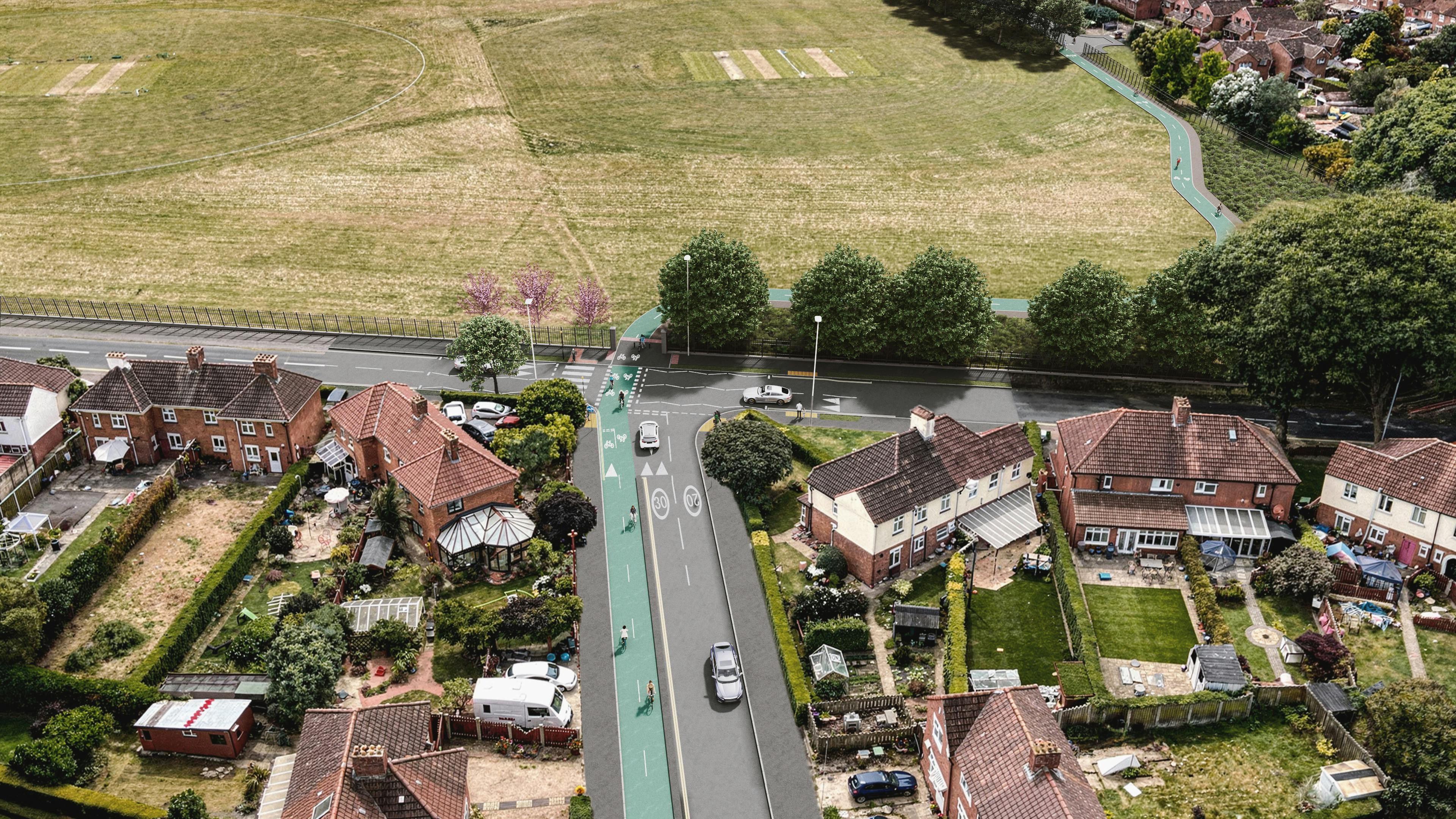
The proposed route travels along Stroud Road, King Edward's Avenue, The Oval, through Tuffley Park, Podsmead Place, Laburnum Road, Podsmead Road and alongside Cole Avenue where it will link to Tuffley Lane.
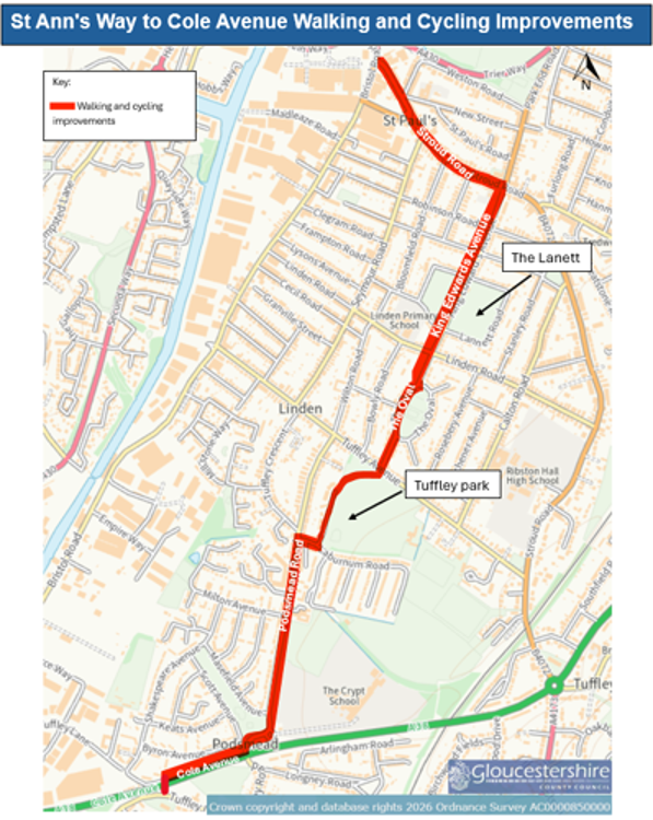


This route connects large residential areas with the city centre, Quays and Docks as well as key destinations including schools such as The Crypt School and Linden Primary School, and green spaces such as The Lannett, The Oval, Tuffley Park and Scott Avenue Open Space.


The route improvements will include:

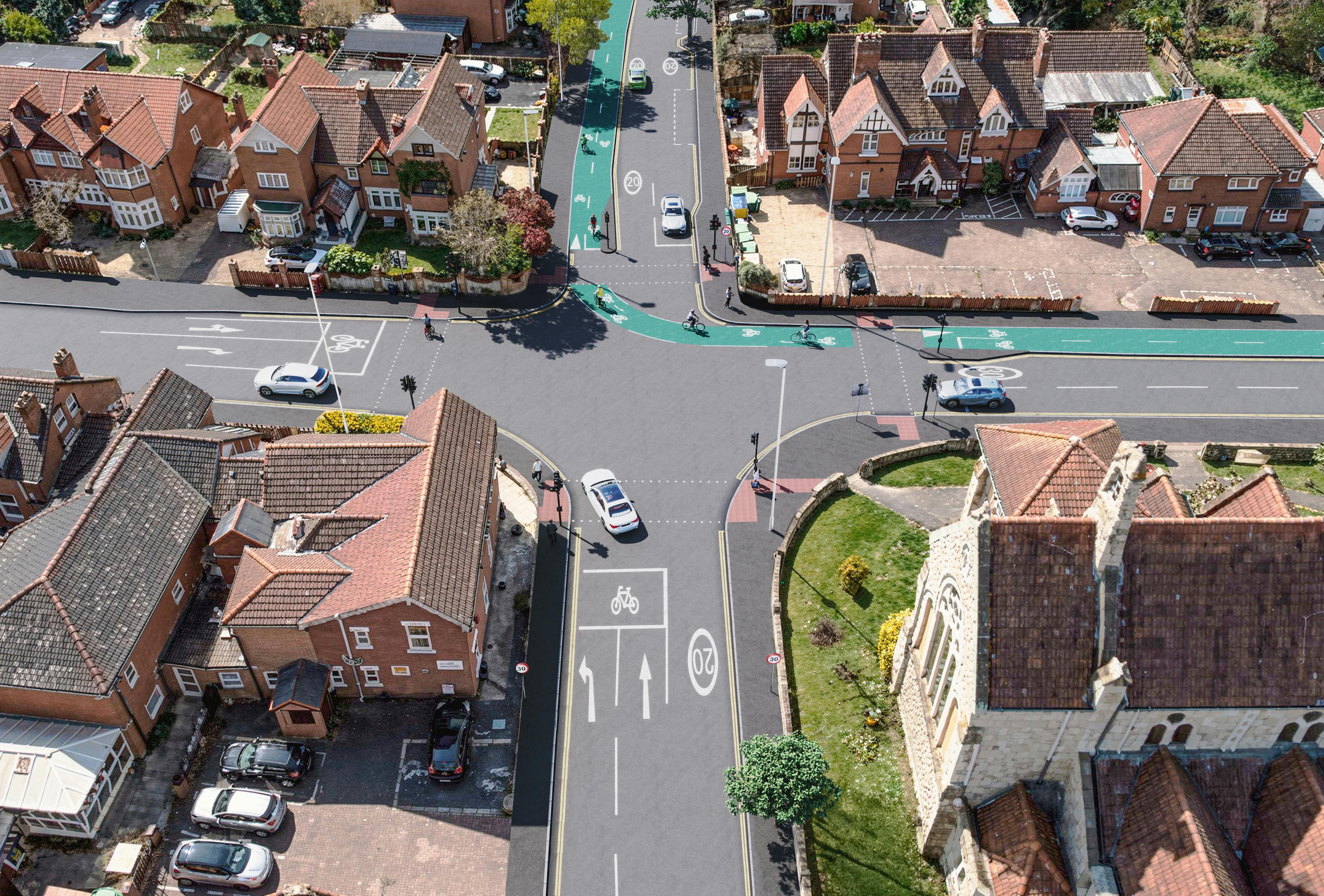
  • New segregated cycleway.
  • Pedestrian route improvements.
  • New and improved crossing facilities for cyclists and pedestrians, including new signalised crossings at junctions and at access points to Tuffley Park and The Lannett.
  • Proposed new surfaced cycle and footway through Tuffley Park.
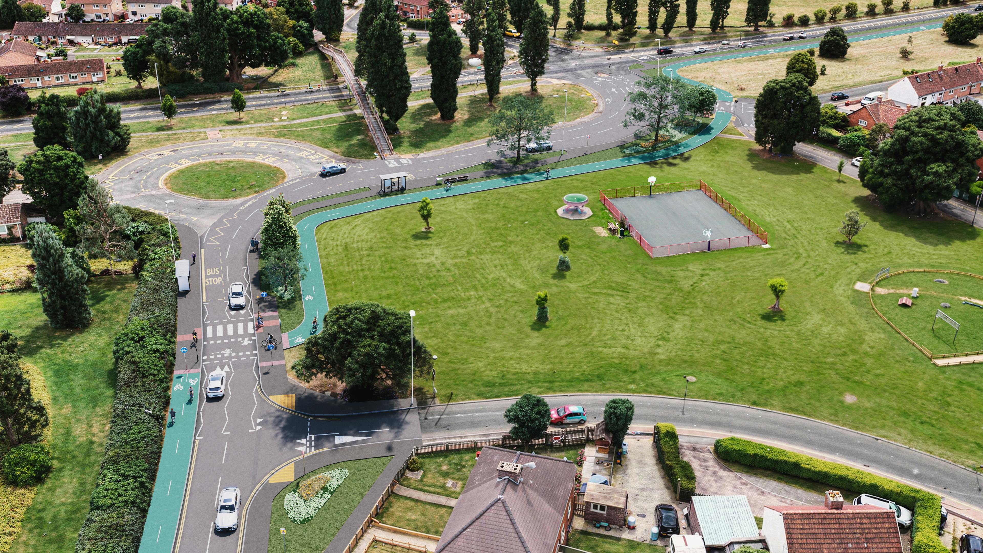
  • Improved pedestrian access to public transport.


The Oval

Three options are being presented for The Oval:

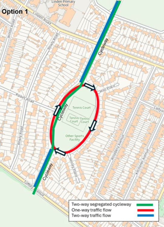
Option 1: A one-way traffic flow is introduced around The Oval park in a clockwise direction, with the new segregated two-way cycleway continuing along the west side of The Oval.

This enables the segregated two-way cycleway to continue along the most direct route.

Option 2: A mixed travel street is introduced on the west side of The Oval, with two-way traffic flow remaining.

This would provide a safer street for pedestrians and cyclists. Measures would be introduced to slow vehicles. Cyclists would be able to remain travelling on the most direct route. Two-way traffic flow would remain around The Oval.

With these measures being introduced on the main through route for vehicles, the route may become less desirable and convenient for motorists, leading to a reduction in through traffic.

Option 3: A mixed travel street is introduced on the east side of The Oval, with two-way traffic flow remaining.

This would provide a safer street for pedestrians and cyclists. Measures would be introduced to slow vehicles.. Two-way traffic flow would remain around The Oval

Please see scheme plan drawings for more details on the three options.


Overview

  • Forms part of the wider Gloucestershire Cycle Spine, strengthening connections between housing and schools, parks, City Centre, Quays and Docks.
  • Informed by planning and feasibility work, targeting a high-demand corridor where improvements can deliver the greatest benefits.
  • Responds to a busy, constrained section, supporting competing movements including general traffic, buses, and local trips.
  • Delivers infrastructure upgrades, segregated two-way cycleways, zebra crossings and junction tables to enhance safety and clarity.
  • Addresses gaps in existing provision, which currently favour more confident users despite strong demand for walking and cycling.
  • Improves access and inclusion, making the route safer and inclusive for a range of users supporting increased active travel.
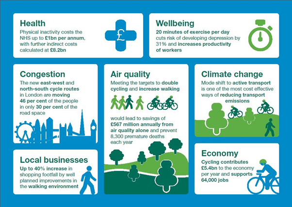

Source – Cycling and Walking Investment Strategy, Department for Transport (2018)

How to respond

To respond to this survey click on the link below.


Take Survey

The survey can also be made available as a hard copy via post, please contact majorprojects@gloucestershire.gov.uk(External link) or telephone 08000-514514.

The survey closes on Wednesday 23rd September.

The St Ann Way to Cole Avenue walking, wheeling and cycling improvements scheme forms part of the Gloucestershire Cycle Spine, a route extending across the county from Stroud in the south to Bishop's Cleeve in the north. It will contribute to a significant cycling and walking network across the Gloucestershire County, improving quality and connectivity.

The St Ann Way to Cole Avenue scheme will provide full access to the 26-mile cycle spine from the St Ann's Way / Bristol Road junction to Cole Avenue and Tuffley Lane. The scheme will support a greener Gloucestershire, help reduce carbon emissions, supporting improvements to public health and making it easier for people to cycle, walk and wheel to work, homes and key destinations.

Walking and cycling have great health and wellbeing benefits. If more people walked, cycled or used public transport, it would lead to less congestion. Furthermore, exercising 20 minutes per day cuts risk of developing depression by 31% and increases productivity.

By providing a high quality infrastructure, we hope to see a change from one form of transportation to another. This shift is one of the most effective ways how to reduce transport emissions and noise pollution.

Route and overview

The route will run between the St Ann Way / Bristol Road junction and Cole Avenue, linking into Tuffley Lane, and provide a direct connection to both recently completed and planned sections of walking and cycling improvements through Gloucester City Centre.

The proposed route travels along Stroud Road, King Edward's Avenue, The Oval, through Tuffley Park, Podsmead Place, Laburnum Road, Podsmead Road and alongside Cole Avenue where it will link to Tuffley Lane.


This route connects large residential areas with the city centre, Quays and Docks as well as key destinations including schools such as The Crypt School and Linden Primary School, and green spaces such as The Lannett, The Oval, Tuffley Park and Scott Avenue Open Space.


The route improvements will include:

  • New segregated cycleway.
  • Pedestrian route improvements.
  • New and improved crossing facilities for cyclists and pedestrians, including new signalised crossings at junctions and at access points to Tuffley Park and The Lannett.
  • Proposed new surfaced cycle and footway through Tuffley Park.
  • Improved pedestrian access to public transport.


The Oval

Three options are being presented for The Oval:

Option 1: A one-way traffic flow is introduced around The Oval park in a clockwise direction, with the new segregated two-way cycleway continuing along the west side of The Oval.

This enables the segregated two-way cycleway to continue along the most direct route.


Option 2: A mixed travel street is introduced on the west side of The Oval, with two-way traffic flow remaining.

This would provide a safer street for pedestrians and cyclists. Measures would be introduced to slow vehicles. Cyclists would be able to remain travelling on the most direct route. Two-way traffic flow would remain around The Oval.

With these measures being introduced on the main through route for vehicles, the route may become less desirable and convenient for motorists, leading to a reduction in through traffic.

Option 3: A mixed travel street is introduced on the east side of The Oval, with two-way traffic flow remaining.

This would provide a safer street for pedestrians and cyclists. Measures would be introduced to slow vehicles.. Two-way traffic flow would remain around The Oval

Please see scheme plan drawings for more details on the three options.


Overview

  • Forms part of the wider Gloucestershire Cycle Spine, strengthening connections between housing and schools, parks, City Centre, Quays and Docks.
  • Informed by planning and feasibility work, targeting a high-demand corridor where improvements can deliver the greatest benefits.
  • Responds to a busy, constrained section, supporting competing movements including general traffic, buses, and local trips.
  • Delivers infrastructure upgrades, segregated two-way cycleways, zebra crossings and junction tables to enhance safety and clarity.
  • Addresses gaps in existing provision, which currently favour more confident users despite strong demand for walking and cycling.
  • Improves access and inclusion, making the route safer and inclusive for a range of users supporting increased active travel.


Source – Cycling and Walking Investment Strategy, Department for Transport (2018)

How to respond

To respond to this survey click on the link below.


Take Survey

The survey can also be made available as a hard copy via post, please contact majorprojects@gloucestershire.gov.uk(External link) or telephone 08000-514514.

The survey closes on Wednesday 23rd September.

Page last updated: 14 Aug 2026, 04:59 PM