

FAQs
- Replacing the concrete wall with railings will help deter anti-social behaviour in the park.
- Railings will allow a more open view into the park and through the trees, improving Tuffley Avenue visually and making the park a more appealing place to visit.
- Railings will provide better visibility between those entering and leaving the park and between those crossing Tuffley Avenue and vehicles travelling along it. This will ensure an improvement in safety for all park and road users.
- Structural surveys have identified that the wall is starting to deteriorate and becoming a safety risk. It therefore would require significant repairs or replacement for this reason alone.
- Scheme website – www.gloucestershire.gov.uk/stannway-coleaveneue
- Gloucestershire Cycle Spine newsletter – sign up via the scheme webpage.
- Gloucestershire County Council social media channels and media releases.
How is the scheme being funded?
The scheme is being funded through a combination of government and local funding sources. This includes funding from the Department for Transport's Active Travel England (ATE) programme, alongside contributions from the Gloucester, Cheltenham and Tewkesbury Joint Community Infrastructure Levy (CIL).
The Active Travel England funding is designated for active travel schemes only and cannot be used for other highway works such as pothole repairs or general maintenance. Gloucestershire County Council went through a rigorous bidding process to secure the funding from central government and had this been unsuccessful, the money would have been allocated to other local authorities for cycling schemes elsewhere in England.
Community Infrastructure Levy funding comes from developer contributions and is used to help deliver infrastructure needed to support growing communities.
Who will use the cycleway and is there a demand for it?
This scheme is part of a wider vision to create a greener, healthier and better-connected Gloucester, where more people can choose to walk, wheel or cycle for everyday journeys.
There is clear demand for improved cycling infrastructure through the area. The Gloucester to Stroud Feasibility Study identified a high propensity to cycle within Gloucester and along the south Gloucester corridor, with significant potential for cycling levels to increase if safer infrastructure is provided.
The new cycleways will be suitable for all users, including the young, elderly, disabled and the less mobile. The route will provide separation from traffic wherever possible, to further attract those who would previously not have considered cycling or did not feel confident to cycle along the road.
The cycleway would be used by local residents travelling to work, education, leisure destinations, shops and services, as well as leisure cyclists travelling through the area.
Recent Gloucestershire Cycle Spine data demonstrates the impact of high-quality cycling infrastructure. Cycle counters at the north subway near Arle Court Roundabout in Cheltenham and along the B4063 corridor have shown percentage increases of around 70% from pre-pandemic levels. These figures evidence that when safe, attractive routes are provided, more people choose to cycle.
Why has this route been chosen and not others such as Bristol Road?
This route via Stroud Road, King Edwards Avenue, Tuffley Park and Podsmead Road was chosen because it better serves many local neighbourhoods and schools, provides easier access to everyday destinations, and offers greater opportunities to create a safer and more attractive environment for walking, wheeling and cycling.
Bristol Road was considered as part of the feasibility study and while it is an alternative route, it has limited space to accommodate both high-quality walking and cycling facilities and future bus improvement schemes.
How does this route link to other walking and cycling routes in the area?
The proposed route between St Ann Way and Cole Avenue will connect with a range of existing and planned improvements across the city, including links through the city centre, Black Dog Way, the B4063 corridor and future routes to the south. Together, these schemes are helping to build a joined-up network that makes travelling by walking, wheeling or cycling safer, easier and more convenient.
By filling a key missing link in the network, the scheme will support the development of Gloucester's wider cycling network and contribute to Gloucestershire’s strategic cycle spine. This will improve access to homes, schools, workplaces, shops and local services, giving people more options for how they travel and helping to reduce reliance on the car for shorter journeys.
As part of a wider programme of investment in active travel, the scheme will help create better connections across the city, making it easier for people to move around Gloucester whether walking, wheeling or cycling.
Why do you have to remove parking spaces?
To deliver the proposed improvements, space is required within the existing highway boundary to accommodate a new cycle route along with pedestrian facilities. The road width is limited in some locations, and it is not possible to safely provide the cycle and walking infrastructure while retaining all existing on-street parking in these locations.
Parking surveys have been undertaken to understand current parking demand and inform the design. The scheme has sought to minimise the loss of parking wherever possible while balancing the need to provide safe and effective infrastructure for all road users.
The proposed changes aim to create a safer and more accessible route for people walking, wheeling and cycling, helping to encourage sustainable travel and improve connections along the corridor.
What consideration has been given to parking provision on Stroud Road and the surrounding area?
A parking survey was undertaken on Stroud Road and the surrounding side roads to understand existing parking demand and identify opportunities to reduce the impact of the proposed changes.
The survey findings have informed the design process and helped identify where parking can be accommodated and where alternative provision may be available within nearby streets.
The project team has also reviewed existing parking restrictions in the surrounding area and, where appropriate, has proposed shortening sections of double yellow lines to create additional on-street parking opportunities.
The scheme seeks to balance parking needs with the need to provide a safe and continuous active travel route, and the design has been developed to minimise parking impacts wherever reasonably possible.
The safety of all users has been a key consideration throughout the design process, and the scheme will continue to be reviewed as it progresses to ensure it meets the needs of the local community.
Are there any plans for banned traffic movements?
As part of the scheme, a ban of turning right from Stroud Road into King Edwards Avenue is proposed through revised traffic signal arrangements.
Surveys have confirmed that the right-turn movement carries relatively low traffic volumes. Alternative access routes through the area will remain available, meaning the impact on access is expected to be minimal. Removing this movement reduces conflicts between vehicles, prevents right-turning traffic from delaying traffic through movements, and allows the junction to operate more efficiently.
This change helps improve overall traffic flow, makes more effective use of available traffic signal green time, and supports the introduction of the proposed cycle infrastructure while maintaining acceptable junction performance.
What are the proposals for traffic at The Oval?
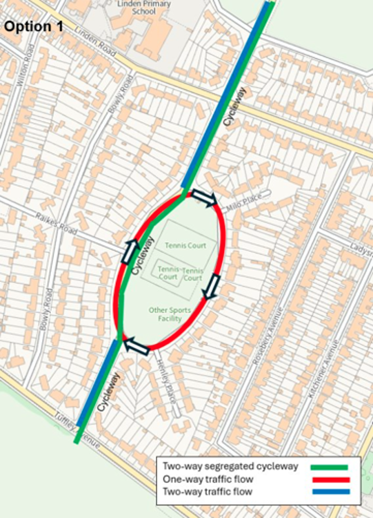
There are three options being considered for The Oval:
Option 1: A one-way traffic flow is introduced around The Oval park in a clockwise direction, with the new segregated two-way cycleway continuing along the west side of The Oval.
This enables the segregated two-way cycleway to continue along the most direct route.
Option 2: A mixed travel street is introduced on the west side of The Oval, with two-way traffic flow remaining.
This would provide a safer street for pedestrians and cyclists. Measures would be introduced to slow vehicles. Cyclists would be able to remain travelling on the most direct route. Two-way traffic flow would remain around The Oval.
With these measures being introduced on the main through route for vehicles, the route may become less desirable and convenient for motorists, leading to a reduction in through traffic.
Option 3: A mixed travel street is introduced on the east side of The Oval, with two-way traffic flow remaining.
This would provide a safer street for pedestrians and cyclists. Measures would be introduced to slow vehicles.. Two-way traffic flow would remain around The Oval
Please see scheme plan drawings for more details on the three options.
What is proposed in Tuffley Park?
The proposals for Tuffley Park include a new surfaced segregated cycleway and footway through the park and improved access points into and out of the park.
This new path will travel around the northwest corner of the park, linking the route between Tuffley Avenue and Podsmead Place.
A new access point will be provided at Podsmead Place and the access at Tuffley Avenue will be improved, to enable it to be easily accessible for all park users whether walking, wheeling or cycling. A new parallel pedestrian and cycle crossing will be installed on Tuffley Avenue linking the park with The Oval.
We are working with Gloucester City Council to identify any opportunities for additional tree planting and wildflower meadows, along with any locations for bench seating along the route.
These improvements will help to make the park more accessible and enjoyable for all, whilst providing a safe route through the area.
As part of the project we are proposing to remove the current concrete park wall along Tuffley Avenue and replace it with metal railings, similar to those found around other urban parks.
There are a number of reasons why this change is looking to be made:
Will you be removing trees or hedges?
There are currently no plans to remove any trees as part of the proposed walking and cycling improvements.
The scheme also provides an opportunity to enhance the local environment. We are working alongside Gloucester City Council to identify opportunities for additional tree planting and wildflower areas within open spaces along the route, including The Lannett, Tuffley Park and Scott Avenue Open Space, where possible.
To enable construction, some sections of hedge along Podsmead Road will need to be cut back and, in some locations, removed. Where hedges are removed, they will be replanted following the completion of construction works to restore the green boundary.
We are working closely with local landowners, including Gloucester Athletics Club and The Crypt School, to ensure that any planting and reinstatement is carried out in a way that meets their requirements and maintains the character of the area.
Overall, the aim is to deliver the scheme while minimising impacts on existing greenery and creating opportunities for additional planting and biodiversity improvements along the route.
Is a lower speed limit being introduced?
There are proposals to introduce a 20mph speed limit on Stroud Road between Bristol Road and Clifton Road. This will ensure vehicle speeds remain low on what will become a one-way road and improve road safety for all users.
Gloucestershire County Council is currently developing wider plans to reduce speed limits across Gloucester and the county, with roads within this project falling within those broader Gloucester and county-wide ambitions. Any proposals for further speed limit reductions will be fully consulted on.
Will the roads remain wide enough for two vehicles to pass?
The proposed carriageway widths have been designed in accordance with highway design standards and will not be reduced below the minimum widths required for their intended use. This will allow two-way traffic, including larger vehicles such as buses, to continue operating safely.
Are the shared use paths safe?
Shared use paths are required in some small sections where site constraints prevent widths required to provide two-way segregated cycleway and footway.
The shared use paths have been designed in accordance with current national design guidance and are subject to independent Road Safety Audits (which include Police representation) throughout the design process and once built.
A range of measures are included with shared use paths to support safe use by both pedestrians and cyclists. These include clear signage, painted markings, tactile paving, crossing facilities, change of surface colour, and defined priority arrangements where appropriate. These features help users understand how the route operates and alert people to potential conflict points.
Shared use paths are widely used across the UK and have been successfully delivered on a number of schemes in Gloucestershire. These include the A435 corridor between Cheltenham and Bishop’s Cleeve and the B4063 corridor between Cheltenham and Gloucester, where they provide safe and convenient routes for people walking, wheeling and cycling.
When will the scheme be built and how long will it take?
The scheme is currently expected to start construction in 2027.
Further details around construction dates, timescales, works phasing and traffic management will be communicated in advance of works starting, once a construction contractor has been appointed.
How can I stay informed about the scheme?
Scheme updates will be provided via the following means: